


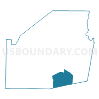
Voting District JACKSON, Highland County, Ohio
About
Outline

Summary
| Unique Area Identifier | 647934 |
| Name | Voting District JACKSON |
| County | Highland County |
| State | Ohio |
| Area (square miles) | 25.83 |
| Land Area (square miles) | 25.83 |
| Water Area (square miles) | 0.00 |
| % of Land Area | 100.00 |
| % of Water Area | 0.00 |
| Latitude of the Internal Point | 39.06364310 |
| Longtitude of the Internal Point | -83.53226750 |
Maps

Graphs
Select a template below for downloading or customizing gragh for Voting District JACKSON, Highland County, Ohio


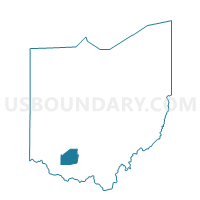
Neighbors
Neighoring Voting District (by Name) Neighboring Voting District on the Map
- BRATTON TOWNSHIP Voting District, Adams County, OH
- Voting District BRUSHCREEK N, Highland County, OH
- Voting District CONCORD, Highland County, OH
- Voting District MARSHALL, Highland County, OH
- SEAMAN PRECINCT, Adams County, OH
- TRANQUILITY Voting District, Adams County, OH
- Voting District WASHINGTON, Highland County, OH
Top 10 Neighboring County Subdivision (by Population) Neighboring County Subdivision on the Map
- Scott township, Adams County, OH (2,180)
- Bratton township, Adams County, OH (1,461)
- Concord township, Highland County, OH (1,415)
- Brushcreek township, Highland County, OH (1,381)
- Washington township, Highland County, OH (1,123)
- Jackson township, Highland County, OH (1,094)
- Marshall township, Highland County, OH (1,029)
Top 10 Neighboring Unified School District (by Population) Neighboring Unified School District on the Map
- Adams County/Ohio Valley Local School District, OH (24,029)
- Hillsboro City School District, OH (16,550)
- Bright Local School District, OH (4,960)